
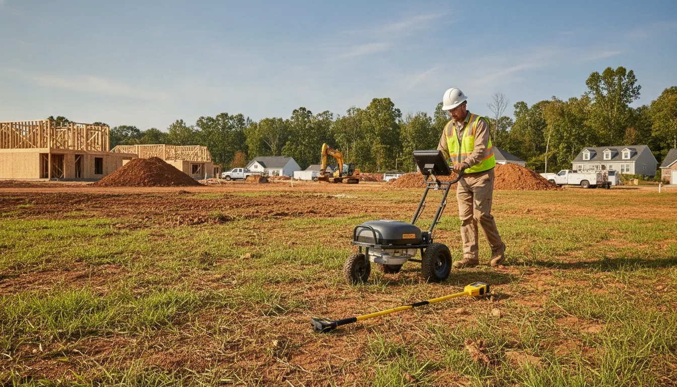
Underground utility records are not always complete, and a clear surface can conceal lines that matter to the next excavation. Ground penetrating radar (GPR) adds a non-destructive way to investigate that uncertainty by sending electromagnetic pulses into the ground and interpreting reflections from changes in subsurface materials. The result can help crews understand what lies below before work begins, while keeping expectations realistic about soil, depth, and interpretation.
Ground penetrating radar utility locating images subsurface contrasts, so it can support the detection of both metallic and non-metallic utilities. It is especially useful when physical conditions allow adequate signal penetration or when a conductive path is unavailable. Electromagnetic (EM) locating traces signals on conductive lines, while GPR images responses from the surrounding subsurface. Used together, the methods provide complementary information rather than an either-or choice.
The right approach depends on the utility materials, ground conditions, project risks, and level of mapping needed. Understanding how GPR produces useful signals, and where those signals become harder to interpret, is the first step toward planning a more informed locate.
How GPR Supports Utility Locating
Ground penetrating radar (GPR) supports utility locating by sending electromagnetic signals into the ground and recording the energy that returns. When those signals encounter a change in subsurface material, such as a buried object or a boundary between different materials. Part of the energy is reflected back to the antenna. The resulting pattern gives a trained operator information about changes below the surface without opening the ground.
That physical process is different from simply following a visible mark or relying on an old site drawing. A GPR survey produces a subsurface view that can help identify and map utility lines and other buried features. The data is interpreted in relation to the site, the survey path, and the surrounding conditions. In practice, the goal is not to treat every reflection as a confirmed utility. It is to recognize meaningful anomalies, compare them with available records and other locating results, and document the findings clearly.
From reflected signals to a utility map
During a survey, the operator moves the GPR unit across the area of interest along planned passes or a grid. Each pass records how the reflected signal changes from one location to the next. An underground feature can appear as a distinct response across multiple passes. By comparing those responses spatially, the operator can develop a more useful picture of the feature's direction and relationship to nearby site elements.
That information can then be transferred into field marks, drawings, or a digital utility map. A map gives contractors, engineers, and property owners a shared reference before excavation or other subsurface work begins. It can reveal where additional investigation, coordination, or design adjustment is warranted. Federal transportation guidance notes that accurate utility information available early in project development can help designers work around potential conflicts and avoid unnecessary relocations: FHWA utility investigation guidance.
GPR is non-destructive, so collecting this information does not require trenching or cutting through the surface as the first step. It is especially valuable when the project needs a broader understanding of what may be below an active work area, pavement, or finished site. Results still require professional interpretation, because subsurface materials and site conditions affect the quality and meaning of reflections. Used as part of a documented locating process, GPR helps turn subsurface signals into practical information for safer planning.
When Is GPR the Right Tool for a Project?
GPR is most valuable when the site conditions, project scope, or available records leave important questions below ground. Old drawings may be incomplete, utility routes may have changed, or previous work may have introduced lines that are not shown in current plans. Subsurface investigation during planning and early design gives the project team better information before excavation begins, rather than treating historical records as a complete field condition.
GPR can add useful context in several practical situations:
- Uncertain records: Plans may conflict, lack detail, or fail to match field conditions. A GPR scan can identify subsurface responses and possible utility alignments for further interpretation.
- Non-metallic utilities: Plastic and PVC lines may not provide the conductive path needed for electromagnetic locating. GPR can respond to differences between the utility and surrounding material, making it a useful complement to EM locating for a more complete investigation.
- Broad-area mapping: A planned grid or systematic scan can help teams build a visual picture of a work area instead of checking only one proposed trench. GPS-integrated GPR can also support precise utility maps used in project planning and infrastructure management. Results still depend on soil conditions, antenna selection, and professional interpretation.
- Transitions between soil and concrete: Work that moves from an open excavation area to a slab, roadway, foundation, or other hard surface may require different scanning considerations. GPR can help investigate the concrete or slab before coring, cutting, anchoring, or connecting work. SafeLine's concrete scanning and GPR service page covers this related application.
GPR is not a reason to set aside electromagnetic locating. EM is often effective for tracing conductive lines, while GPR contributes a subsurface image that can reveal non-conductive materials and other anomalies. Using both methods can help investigators compare signals, follow likely routes, and identify areas that deserve closer review. For projects involving privately owned lines, consider arranging private utility locating services before the digging plan is finalized.
Project urgency can also influence the response plan. SafeLine describes its locating service as 24/7 emergency-ready, so an active utility conflict or an unexpected condition may warrant a prompt field assessment rather than an informal guess. Even on an urgent schedule, the team should document limitations and confirm what the scan can reasonably support. GPR detection depth varies with soil composition and antenna frequency, with SafeLine's reference materials noting typical utility locating depths of roughly 3 to 10 feet under applicable conditions. That range is not a guarantee for a particular site.
How GPR Complements Other Locating Methods
GPR is one part of a professional utility investigation, not a universal replacement for every locating method. It can add subsurface imaging where records are incomplete, a target may be non-conductive, or an electromagnetic signal is unavailable. The right combination depends on the utility materials, site conditions, project risk, and information the team needs before work begins.
For a focused comparison of detection principles, signal access, material limitations, and project-selection criteria, read SafeLine's guide to comparing GPR and EM locating methods. That comparison covers the method-selection question, while this guide remains focused on how GPR data is collected, interpreted, and applied.
What GPR responds to
GPR sends electromagnetic pulses into the ground and records energy reflected from boundaries where subsurface materials differ. These dielectric contrasts can create a detectable response even when a utility is not made of metal. That makes GPR useful when investigating plastic or PVC infrastructure. Although the strength and clarity of a response depend on the contrast with surrounding soil and the site conditions. The U.S. Environmental Protection Agency describes GPR as a method that transmits radio wave pulses into the ground to study the subsurface. With reflections occurring at interfaces between materials with different electromagnetic properties: EPA guidance on GPR.
Why professional interpretation matters
GPR findings are evaluated with site records, surface features, planned excavation areas, and other field evidence. A professional team may also use electromagnetic locating to trace conductive utilities and compare route information with GPR responses. The purpose is to build a more useful, documented picture of the site, not to treat a single instrument reading as a confirmed utility.
How Soil and Utility Materials Affect GPR Results
Ground penetrating radar utility locating does not produce the same response in every soil or around every utility. GPR sends electromagnetic pulses into the ground and records energy reflected when those pulses encounter boundaries between materials with different electrical properties. Dielectric permittivity and electrical conductivity are especially important to the strength and clarity of the returning signal. The U.S. Environmental Protection Agency explains how GPR reflections form.
Moisture, clay, and conductivity can limit the signal
Dry, sandy soils or rocky terrain generally offer more favorable conditions for GPR. By contrast, saturated clay can absorb or attenuate the signal before it travels far enough to reveal a deeper target. Other high-conductivity materials can have a similar effect. The result may be weaker returns, reduced detail, or a shallower practical imaging range. This is why a depth estimate should never be treated as a fixed promise based only on the equipment model.
Surface conditions can also change during a project. Recent rain, irrigation, a high water table, fill material, and layers of soil with different compositions may all affect how energy moves through the site. Two areas only a short distance apart can therefore produce different data. A qualified operator evaluates the radar response in its actual setting rather than applying a generic depth assumption.
Utility material changes the expected response
GPR responds to physical and electrical contrasts, not to a utility label alone. Metal and concrete often create strong reflections because their properties differ substantially from surrounding soil. Plastic and PVC can also produce detectable responses, but the result varies with the pipe, its contents, surrounding material, burial conditions, and the quality of the contrast. GPR can help investigate both metallic and non-metallic utilities, including targets that may not provide a conductive path for electromagnetic locating.
That capability does not make GPR a replacement for EM locating. SafeLine uses GPR and EM together because the methods respond to different characteristics. EM is useful for tracing conductive lines, while GPR supplies an image of subsurface contrasts that can add context around non-conductive or difficult-to-trace targets.
Antenna frequency requires a site-specific tradeoff
Antenna frequency affects the balance between resolution and penetration. Higher-frequency antennas generally show smaller features with greater detail but may not reach as deeply. Lower-frequency antennas can provide greater penetration potential, usually with less fine resolution. The appropriate selection depends on the target, soil, surface access, and the level of detail required.
Calibration, controlled scanning, and experienced interpretation matter as much as frequency selection. A professional locate should account for the site's actual soil response, compare patterns across scan lines, and document limitations before results are used for excavation planning. The goal is useful, defensible subsurface information, not an unsupported certainty.
What GPR Cannot Tell You on Its Own
Ground penetrating radar utility locating is a powerful way to identify subsurface patterns, but the scan is not a perfect underground photograph. GPR records reflected energy and produces an image that must be interpreted in the context of soil conditions, site history, utility construction, and other field evidence. A responsible locate treats the data as meaningful evidence, not as permission to assume that every anomaly is a pipe or that every line has been found.
Site conditions can obscure or complicate the picture
Urban and developed sites often contain overlapping reflections from utilities, rebar, foundations, pavement changes, rocks, debris, and other non-utility objects. When several features occur close together, their responses can be difficult to separate. A strong reflection may indicate a material contrast without identifying the object's purpose. That is why the visual subsurface map is useful for evaluating potential utility locations and hazards. But it does not independently establish ownership, material, or function for every feature.
Orientation also matters. A utility running across the antenna path may produce a clearer response than one aligned with the travel direction. Irregular surfaces, restricted access, nearby structures, and inconsistent survey spacing can create additional gaps in coverage. Moisture and clay can attenuate the signal, while antenna selection creates a practical tradeoff between resolution and penetration. Depth estimates therefore vary with calibration and conditions. They should be treated as field measurements with expected uncertainty, not as guaranteed values.
Interpretation requires corroboration
Experienced locators compare GPR responses with an electromagnetic (EM) sweep, visible site features, available records, surface indicators, and the planned excavation area. EM locating can trace signals on conductive utilities, while GPR can provide useful responses from both metallic and non-metallic infrastructure. Using both methods helps address the limitations of either one and gives the field team more context when data are ambiguous.
SafeLine utilizes GSSI UtilityScan equipment and documents findings as part of a professional locating process. The goal is to identify and communicate probable utility paths, conflicts, and areas requiring caution before work begins. Results may include confidence limits or recommendations for additional verification, such as targeted exposure within an appropriate engineering or excavation plan. This transparent approach supports safer decisions without promising perfect detection, guaranteed depth, or prevention of every possible strike. For more detail on how a visual subsurface map supports pre-excavation planning, review SafeLine's private utility locating services.
How a Professional Utility Locate Uses GPR
- Review records and site conditions. The process begins with the project scope, available utility records, proposed excavation areas, and a site walk. The locating professional looks for visible evidence such as utility structures, pavement changes, service entries, and access constraints. Records help establish a working plan, but they are not a substitute for field investigation. This early review is especially important for private utility locating, because privately owned lines may not be included in public marking requests. SafeLine's private utility locating services are designed to identify and mark those site-specific features before work begins.
- Perform an electromagnetic sweep. The technician uses electromagnetic, or EM, locating to trace signals on conductive utilities. This method is useful for many metallic lines and power cables, but it depends on a conductive path or a usable signal. EM and GPR are complementary methods, not competing choices. Using both helps the field team compare signal-based results with physical subsurface responses and identify areas that need closer examination.
- Scan with GPR where appropriate. A GPR unit is moved across planned scan paths or a defined grid at approximately walking speed. It sends electromagnetic pulses into the ground and records reflections created by contrasts between buried objects and surrounding materials. This can support the detection of metallic and non-metallic utilities, including situations where EM tracing alone may not produce a usable signal. The technician selects scan areas, antenna settings, and coverage based on the project and site conditions. Saturated clay, moisture, high-conductivity materials, surface clutter, and overlapping responses can limit the quality or depth of the data, so GPR findings require professional interpretation.
- Correlate findings and mark or map them. Results from the EM sweep, GPR scans, records, and site observations are compared rather than treated as isolated answers. Consistent indications can be marked in the field or incorporated into a project map. For larger design and construction efforts, this work may support the commercial SUE service guide, which explains how surveying, civil engineering, and geophysical information improve the usefulness of underground utility data. The objective is practical planning, not a promise that every subsurface condition can be resolved from the surface.
- Document limitations and communicate the results. The final deliverable should identify the areas investigated, methods used, marked or mapped findings, and conditions that affected interpretation. Soil, access, signal quality, depth, and congestion can all influence what a survey shows. Clear documentation gives the project team a basis for coordinating excavation, design, and follow-up verification. It also makes the limits of the investigation visible, so contractors, engineers, owners, and facility teams can make informed decisions before digging.
Frequently Asked Questions
Can GPR detect underground utilities?
Yes. Ground penetrating radar can identify both metallic and non-metallic utilities by recording reflections created by contrasts between buried objects and surrounding soil. It is especially useful for locating infrastructure that may not provide a conductive path for electromagnetic tracing. Results still require trained interpretation and should be considered alongside other site information.
How deep can ground penetrating radar detect?
There is no universal maximum depth. Soil composition and antenna frequency control the usable range. SafeLine's documented guidance places typical utility-locating depths at about 3 to 10 feet, but saturated clay, conductive materials, clutter, and the selected antenna can reduce effective penetration. A field assessment is needed before relying on a depth estimate.
How does GPR support utility mapping?
A systematic scan produces a visual subsurface profile that can help correlate suspected utility paths, crossings, and potential hazards before excavation. When combined with site records, surface features, EM results, and field documentation, GPR supports a more defensible map. The ASCE 38-22 framework provides industry guidance for investigating and documenting existing utilities.
Does soil condition affect GPR results?
Yes. Dry, sandy soils and rocky terrain are generally more favorable, while saturated clay and other high-conductivity materials can weaken signals and reduce usable depth. Frequency also involves a tradeoff between penetration and resolution. A professional operator evaluates the site conditions and interprets the data within those limitations.
Schedule a Safer Subsurface Review
Before excavation or construction, a coordinated review can help clarify what existing records may not show. SafeLine Subsurface combines GPR and EM locating with subsurface mapping to support practical planning for private utilities, non-metallic lines, and other underground features. Call SafeLine Subsurface at 866-677-2335 to discuss your locating, GPR, EM locating, or mapping need.